Showing posts with label Hilo. Show all posts

Sunday, August 7, 2011

A Hilo “Luau” on the Island of Hawaii

A luau is a Hawaiian feast or party usually featuring food such as poi, kalua pig, poke, lomi salmon, opihi and haupia, along with beer (and rum drinks); and often entertainment, like Hawaiian music and hula.

On July 4th we had some friends over to watch the fireworks over Hilo Bay and decided to turn it into a mini-luau.  For something special, my wife Devany and I wanted to prepare a Cuban style roasted pig, something similar to kalua pig which we have had at several Hawaiian celebrations here.

The word kalua literally means "to cook in an underground oven" and also describes the flavor of food cooked in this manner, i.e., “kalua pig.”  Kalua is an ancient Hawaiian cooking method that uses an imu, or underground oven.

At a traditional luau, a fire using kiawe wood (a species of mesquite tree) is built in a sand or dirt pit (the imu).  It is about six feet long, four feet wide and three feet deep. Rocks are placed in the imu to retain cooking heat after the flames have burned down.  Once the rocks have become extremely hot, the hole is lined with vegetation such as banana leaves.
Imu Ready for Firing
The meat to be cooked (in this case a suckling pig) is salted, rubbed with herbs, stuffed with more hot rocks, and covered with ti and banana leaves.  To maintain even heating and to retain the meat's natural moisture, it is covered first with wet burlap, then with a layer of sand or soil.  The meat is then left to cook in the pit for six to seven hours.

Since we did not particularly feel like digging up our yard, we did perhaps the next best thing which was to use a pig roasting box purchased from “La Caja China”.  The La Caja China is a box designed to accommodate the roasting of a marinated whole pig, butterfly cut.  The pig is placed inside the box, and charcoal is placed on top of the lid to roast the meat inside.  After about five hours the pig is well roasted and tastes amazing.

                                    
We were able to buy the big from a local abattoir in Hilo not far from our house.  It probably weighed about 60 pounds (80 pounds live weight) and barely fit in the La Caja China.

Devany had marinated the pig in a solution of sour orange and garlic with spices for 24 hours before the day of its cooking.  She also injected the pig with more of the marinade just before the coals were started.  Her recipe for the (marinade) is as follows:

2 gallons of orange juice
1 quart of lime juice
1 cup of dried chopped oregano
¼ cup garlic salt
3 cups of chopped garlic
½ cup of cracked black pepper
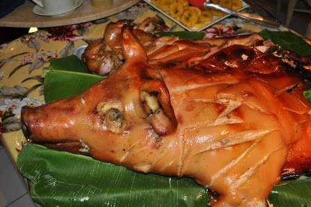
At the "Luau"
                                 
The results were well enjoyed by all, and while not quite a real luau, it certainly was a great feast.  I’ll discuss some of the other gastric elements to a traditional luau in subsequent postings.

Monday, May 23, 2011

Golfing on the Island of Hawaii (the Big Island)

Golf is a great game, in fact I have been playing it since I was twelve years old, but on some days it can be less than exhilarating – like when you shoot your weight rather than your age (Bob Hope's quote).  But for those who love the game like I do, there are few places better to live or visit than the Big Island.

Fairmont Orchid Golf
We live on the windward/East side of Hawaii Island in Hilo. While the best golf resorts are on the island’s other side (see my earlier entry All Around the Island),  the nearby Hilo Municipal public course is quite challenging with its multiple elevated greens and lava creeks that come into play on about twelve holes (slope: 121).  The course is well maintained and playing pressure is about average.  And unbelievably, if you are a resident over 60 years of age the monthly green fees are only $24 for unlimited play.
Courses on West Side of BI (Google)
Within 45 minutes of our house are two other public courses, one in Volcano and the other in Waimea, plus a nine hole course in downtown Hilo near the oceanside.  Volcano Country Club is beautiful and located at about 4,200 feet you can get some really nice drives (slope: 124).  Waimea Country Club is challenging for the beginner given its gorse-like roughs that make finding errant balls almost impossible, but a lovely course (slope: 132 ).
Four Seasons Golf
Most of the serious golf action is located on the drier west side nearer Kona/Kiluea and the luxury golf resorts around Waikoloa Bay.  The only three that I have been lucky enough to play have been the Hapuna Golf Club, Big Island Country Club and the Waikoloa Village Golf Club.  All were magnificent.

The Big Island course was designed by Pete and Perry Dye and features an island green (slope: 136).  Unfortunately, as I recall, no one in my foursome avoided the water.
Big Island Country Club
The other eight courses that I hope to play one day (listed from Kona northward):

+  Kona Country Club – Mountain and Ocean Courses
+  Makalei Golf Club
+  Hualalai Golf Club (near Hawaii’s only five-star resort, the Four Seasons) – designed by Jack Nicklaus
+  Waikoloa Beach Resort – Beach Course (Robert Trent Jones designed) and Kings’ Course (Tom Weiskopf and Jay Morrish Scottish links-style )
+  Mauna Lani Resort – North and South Courses (the favorite of Hilo’s golf guru George at Golf Treasures) 
+  Mauna Kea Golf Course

George at Hilo Golf Treasures
Numerous golf course vacation packages are available.  And for more information on these and other golf courses on the Big Island, check out the following link: Big Island Golf.  And, most important, if you are in town and need someone to play, let me know!  All of the above courses are closer than two hours from our Hilo home.

Monday, April 18, 2011

The Deep Blue Sea

I grew up vacationing and fishing on a lake near Dayton, Ohio (Grand Lake St. Mary’s) that was about nine miles long by three miles wide and had a depth of less than seven feet.  So you can imagine my disconnect now when looking out our backyard and seeing humpback whales swimming past and ocean going cruise vessels entering  the Hilo Harbor.

"Valentine" in Backyard
This led me to wonder just how deep the ocean was off of our lanai, which in turn led me to the NOAA (National Oceanic and Atmospheric Administration) site which was brought to my attention by a friend of mine in Marine Science at the University of Hawaii - Hilo:  http://www.nauticalchartsonline.

www.NOAA
So the ocean seems to be about 14 feet deep near our cliff, then increasing to 25 feet in depth and quickly to 34 feet.  Beyond that the water becomes about 90 feet in depth which must be fine for humpback whales.  It seems that humpback whales seem to prefer "shallow/protected" waters and spend the majority of their lives in waters that are 300 feet or less, and in this case, considerably less  than 300 feet.  http://www.whalewatchmaui.com/maui.html
Credit: Devany Vickery-Davidson

From deep water on the north, there is a ship channel to the inner harbor edge to the wharves in Kuhio Bay. A Federal project provides for an entrance channel 35 feet deep and a harbor basin of the same depth in Kuhio Bay. Channel and basin are maintained at or near the project depth. www.NOAA


As you can see, our weekly Tuesday visitor, the “Pride of America,” has a draft of only 26 feet.
www.NCL
Humpback whales and the cruise ships seem to coexist peacefully.  We have even seen whales swimming next to the ship and “porpoising” in and out of the water next to the boat. 
Interestingly, the 20-fathom depth (120 feet) curve is seldom more than one mile from shore in Hawaii and usually not far from the coral reefs that fringe much of the island coastline. The bottom generally pitches off rapidly to great depths from a narrow coastal shelf. Under normal conditions the color of the water changes from a deep blue in the open ocean to a blue-green between the 10- and 15-fathom (60 feet to 90 feet) curves; and bottom features become visible at 6 to 7 fathoms (36 feet to 42 feet).  www.NOAA

Friday, December 10, 2010

Singin’ in the Rain

Yes it does rain often in Hilo and after my last posting on the trade winds it made me wonder even more, “Why?”  Since the wind is coming across the open ocean from the east and then hitting the mountains, it seems the air would pick up moisture as it goes over the volcanoes and drop it on the Kona side of the Big Island.  But no, thanks to the phenomenon of orographic (my spell checker keeps wanting “pornographic”) precipitation the rain drops on Hilo and the Big Island’s east side.

Before defining this let me say that much of the rain comes at night.  For instance, I play golf just about weekly and have not been rained out once; rained on occasionally but not rained out.  And the average temperatures are superb as you can see below.

NOAA
So to recap, in Hawaii, local climates vary considerably on each island due to their topography, divisible into windward (Koʻolau) and leeward (Kona) regions based upon location relative to the higher mountains. Windward sides face the east towards northeast trade winds and receive much more rainfall; leeward sides are drier and sunnier, with less rain and less cloud cover.

The rainfall is caused by orographic precipitation which is when masses of air pushed by wind are forced up the side of elevated land formations, such as large mountains. Upon ascent, the air that is being lifted will expand and cool. This cooling of a rising moist air parcel may lower its temperature to its dew point, thus allowing for condensation of the water vapor contained within it, and hence the formation of a cloud.

If enough water vapor condenses into cloud droplets, these droplets may become large enough to fall to the ground as precipitation. In parts of the world subjected to relatively consistent winds (for example, trade winds), a wetter climate prevails on the windward side of a mountain than on the leeward (downwind) side as the moisture has been removed by the effects of orographic precipitation.

Full Wiki
In the state of Hawaii, Mount Waiʻaleʻale on the island of Kauai is notable for its extreme rainfall, as it has the highest average annual rainfall on earth with 460 inches. http://en.wikipedia.org/wiki/Orographic_precipitation#Orographic


A true-color satellite view of Hawaii shows that most of the vegetation on the islands grows on the north-east sides that face the wind.


Hawaii Islands
The result of this phenomenon on the Big Island is one very green side with waterfalls (the eastern) and one very sunny, dry side (the western).  Most of the resorts are located on the western side and served by Kona International airport.  Waterfalls and beautiful greenery are on the eastern side and served by Hilo International airport.  We prefer life on the “green side,” with visits to the beautiful beaches around Kona. (See East Side/West Side - All Around the Big Island
 for other contrasts.)  And rain does bring these!

Devany Vickery-Davidson

Friday, October 29, 2010

Babe Ruth in Hilo


With the World Series in progress it seems fitting to discuss Babe Ruth’s presence in Hilo on the Big Island -- particularly since his Hilo visit was memorialized in such a spectacular way.  The year was 1933 and The Babe was in Hawaii to play a series of exhibition games against various local teams.
About that same time several park commissioners in Hilo decided that it would be a good idea to have celebrities’ plant banyan tree saplings along the Waiakea Peninsula.  In late 1933, Cecil B. DeMille was on the island filming "Four Frightened People".  Several of the actors planted trees in their own honor, along with Mr. and Mrs. DeMille.  Some eight trees were planted in October 1933. And in addition to the movie stars, one tree was also planted by one of the most famous men in America, Babe Ruth.  This drive, now named Banyan Drive is also known as the "Hilo Walk of Fame.”
Over time probably some fifty trees were planted with many surviving until today having grown into a thick canopy, making it popular for walking.  The Waiakea Peninsula is anchored by the beautiful Liliuokalani Park and Reed’s Bay Beach Park, and not far from the Hilo airport.  The name comes from wai ākea which in Hawaiian means "broad waters,” and sometimes what is now called Hilo Bay was once called Waiakea Bay.
The Banyan tree is an example of a strangler fig that often begins life in the crown of another tree. Its roots grow down and around the stem of the host, their growth accelerating once the ground has been reached. Over time, the roots coalesce to form sort of a pseudotrunk.  Older banyan trees are characterized by their aerial prop roots that grow into thick woody trunks which, with age, can become indistinguishable from the main trunk. Old trees can spread out laterally using these prop roots to cover a wide area.
The first banyan tree in the U.S. was planted by Thomas Alva Edison in Fort Myers, Florida.  The tree, originally only four feet tall, now covers 400 feet.  Robinson Crusoe, in the 1719 novel by Daniel Defoe makes his home in a banyan tree.  Due to the complex structure of the roots and extensive branching, the banyan is also extensively used for creating Bonsai.  Taiwan's oldest living bonsai is a 240-year-old banyan in Tainan.

Wednesday, September 16, 2009

Blog 20 -- Hilo Harbor Breakwater


In 1946, Hilo, Hawaii, was struck by a tsunami generated by an earthquake in the Aleutian Islands; it was struck again in 1960 by a tsunami generated by the great Chilean earthquake. That is why I assumed that the Hilo breakwater was built…..but no, it is much, much older than that.

The Hilo breakwater was actually constructed between 1908 and 1929 upon a submerged reef in Hilo Bay to protect against winter storms. In fact both tsunamis overtopped the breakwater. (A plan to increase its height was rejected partially because no one could assure the public that such a project would indeed protect them from another seismic wave; not to mention questions of aesthetics about a towering wall that would block views to sea.)

Breakwaters

Ok, so what are breakwaters? According the US Army Corps of Engineers they are structures employed to reflect and/or dissipate the energy of water waves, thus preventing or reducing wave action in a protected area. They are used to create sufficiently calm waters in a harbor area, thereby providing protection for the safe mooring, operating, and handling of ships and protection of shipping facilities.

Why Hilo?

The growth of Hawaii during the establishment of sugar plantations and their use of immigrant labor and the up-and-coming visitor industry depended on the systematic development of secure harbor facilities. Hilo Harbor is one of two commercial harbors on the Big Island (the other is Kawaihae on the northwest side of the island). The first recorded improvement in Hilo was a stone pier constructed by an early entrepreneur, Thomas Spencer in 1861.


Hilo Harbor is located at Kuhio Bay, itself a small extension of the larger Hilo Bay. The harbor is two miles from the business district of Hilo and some 194 nautical miles southeast of Honolulu Harbor. Both overseas and inter-island ships and barges make regular calls at Hilo Harbor in addition to scheduled passenger cruise ships.

Blonde Reef

The submerged reef upon which the breakwater is built runs in the shape of a crescent, in a position reversed to the crescent of the bay. The average depth of water over this reef is about 23 feet, with occasional pockets of 40 or more feet depth.

It was named Blonde Reef in 1825 in commemoration of a visit by Lord George Byron, cousin of the poet. He arrived in Hawaii aboard the British frigate, H.M.S. Blonde which was carrying the bodies of Liholiho (King Kamehameha II) and his wife Kamamalu to Honolulu for burial there. The Hawaiian king and queen had died of measles within six days of each other while on a visit to London. Lord Byron proceeded to Maui and Oahu and returned to Hilo with Ka’ahumanu, regent of the kingdom. On their arrival Ka’ahumanu declared that Hilo Bay was henceforth to be known as Byron Bay, and from then on the reef that protects the bay has been known as Blonde Reef in honor of the ship that had returned the bodies of the royal couple to their homeland. (Beaches of the Big Island, John R. K. Clark, University of Hawaii Press, 1985).

Construction of Hilo Harbor Breakwater

The United States entered into a contract on June 12, 1908, for constructing the breakwater at Hilo Harbor. The specifications called for a jetty of the rubble mound type (rubble-mound breakwaters are the largest and most substantial of various breakwater types and are used almost exclusively in offshore and major coastal harbor protection schemes.)

Many stones in the slope walls were required to weigh more than two tons each. And across the top and down the sea side slope, to a point three feet under low water, the stones needed to weigh over eight tons each!


The required weight for the stones sent the contractor nearly thirty miles to Puna, on the east point of the island, to open a quarry. For while the whole island is virtually built of flows of lava rock, and the breakwater itself rests on a reef of it, there are comparatively few places on the slopes of Mauna Loa where rock of this weight could be found in large quantities. Nearly four miles of railroad had to be graded and built across lava flows in order to make connections with the tracks of the Hilo Railroad Company over which the stone was hauled.

The breakwater was completed in three sections respectively in 1910, 1911 and 1929. The third section extended the breakwater to its present length of about 2 miles. After dredging a deepwater channel in 1914 and from 1925-1930, the Hilo Harbor took roughly its present form.

In the 21 years of its construction the breakwater ended up using over 950,000 tons of rock -- truly a feat of engineering and worthy of our esteem for all involved. Mahalo !

Nā pana kēia o Keaukaha

Mai ka palekai a I Leleiwi

Pā mau I ka meheu a nā kūpuna.

Ha’alele aku ‘oe I ka palekai

Kahi māka ‘ika’I e nā selamoku

Lana mālie ke kai’ olu nā lawai’a.

These are the famous places of Keaukaha

From the breakwater all the way to Leleiwi

Resounding to the footsteps of our ancestors.

Your leave the breakwater,

The place visited by sailors.

Where the sea lies calm, the fishermen are pleased.

“Na Pana Kaulana o Keaukaha”

© by Edith Kanaka’ole, 1979


Monday, August 10, 2009

Blog 18 – Arriving in Kona/ Getting to Hilo


The flight was smooth and even arrived early. We had heard several disaster stories about retrieving your pets, so we were amazed when they were released to our care even before our luggage had arrived. As soon as we landed they were taken to a special area and examined by a local veterinarian and our paperwork was checked. She said our documents were in the best shape she’d ever seen, so that might have been part of it, but we were also perhaps lucky. One story we were told was of the vet on duty at the airport being called away for emergency surgery and the pet owners having to wait several hours for her return. That would be stressful.

We had a pre-set confirmed appointment with the vet, whom we spoke with on the phone several times before arriving. Only one vet serves the entire Kona arrival center, so you also need to confirm that she is available at the day and time you want to fly in before booking your flight. Another thing is that you have to have the flight and flight number ahead of time for your application.

Anyway all went well with the pets, so we collected our entire assortment of luggage and I went to get the rental car while

Valentine and Kiwi received beaucoup attention from the passer-bys.


We had a mini-van on this end, so everything fit with relative ease, unlike in California where we were barely able to stuff everything into a “full sized” vehicle.


The drive to Hilo took us about two hours, but we stopped enroute in Waimea for food and household cleaning supplies – which added another hour. The Foodland store there is my wife’s favorite grocery outlet.


We finally pulled into our house very tired and very relieved at about dusk. One of the owners was still there doing some last minute cleaning and our realtor dropped by to welcome us with a bottle of champagne, so we had a little mini-welcome party.

"The View"

They left, and we crashed. Two beds were part of the overall transaction, so all we had to do was make one up and hit the sack. It felt so good to finally be back in Hilo – and best yet, on a one-way ticket.

Saturday, July 18, 2009

Hilo Latitude -- No Attitude


We had a visitor last night from the mainland, a fellow ceramic artist friend of my wife's (East Bay Potter), who actually lives full time on a sailboat in Richmond, California across the bay from San Francisco. We started speculating over some red wine where you would end up if you sailed east or west from Hilo.

I did some research today and learned some wild geography.

First,
Hilo Hawaii is located roughly at 19.7 degrees north of the equator.

Going east we would hit the Mexican city of Manzanillo, its busiest port and located about equidistant between Puerto Vallarta to the north and Acapulco to the south. Manzanillo is also a beach resort and host of a yearly sailfish fishing tournament. Weirdly, the city claims to be also well known for the green flash phenomenon during its sunsets, something I’ve tried to see about a hundred times and was beginning to think was a myth.

Continuing east from Manzanillo at about the same latitude is Vera Cruz, a major port city on the Gulf of Mexico and Mexico’s second largest city. During the Mexican-American war, US forces led by General Winfield Scott took the city on March 29, 1846 after a lengthy siege.

Going west is even more fantastic because we run into "the Oriental Hawaii," which is surprisingly (at least to me), part of China! The “Oriental Hawaii” is an island named Hainan which is the smallest land province in China and located at its southern end. The island has a population of over seven million! According to
travelchinaguide.com, “its natural beauty has gained a good reputation among the visitors and has been widely known around the world.”

Its capital city is Haikou, situated at the north end of Hainan Island, and it is the largest city on the island, located between 19.6 - 20.1 north latitude.

Continuing west across the Gulf of Tonkin, which is utterly evocative of the Vietnam War for most baby boomers, is Thanh Hóa, the capital city of Thanh Hóa Province, a city of nearly 200,000. The
city is located about 85 miles south of Hanoi and considered to be a growing trade and industrial center.

During the Vietnam War US strategic bombing destroyed much of the buildings and infrastructure, the whole city has been totally rebuilt since then.

So who knew? I realize Americans are famous for their lack of knowledge about other countries but this was all quite new to me (and I even know that Tasmania is not a country in Africa). Also on Hilo’s latitude is Mumbai (Bombay) or should I say that we are on theirs
? Aloha.

Wednesday, June 10, 2009

Blog 15 Packing and Getting Ready for the Move

Matson Container Ship on Way to Big Island

At this point, your reminder lists will stretch to well over two pages, e.g., donate books to library, find somewhere for the old computer, plan going away party, fix back door, hold garage sales, etc., etc., etc.

This is probably about when I started to lose it, right after Thanksgiving.  After all we were moving January 5, and I was thinking, “how will we ever get everything done?”  Luckily, my wife was a stabilizing influence.  Remember that before now all I had known were corporate moves.  She had seen the “real deal” several times -- before we had met.


Last Corporate Move -- 2006

We picked a moving company after getting several estimates, and knew that we wanted help packing.  Hardier souls can obviously do this themselves and save considerable money.  Partially as an economy measure we did box some things ourselves and even shipped certain items that we would need until our furnishings arrived and many of our books.

The US Postal Service has a phenomenal price on shipping books.  So after about ten trips to the post office we probably shipped forty boxes of books for maybe $200.

Container Ship and Tug Entering Hilo Harbor

Part of our concern was that when we had our possessions eyeballed by the moving companies, they agreed it looked like a tight fit for a 45-foot container (their biggest).  And we did not want to have to ship two of them.  So moving the books our self was a big help.  Our container ended up 99.5% full (whew ...)!