Tuesday, June 22, 2010

Big Island to Maui -- Crossing the Channel

The Alenuihaha Channel (or the “I'll-end-you, ha-ha” channel), between the islands of Hawaii and Maui, is 26 miles wide in its narrowest part and has sometimes been referred to as the most dangerous channel crossing in the world.


Roughly translated, Alenuihaha means “of very large, trough-like waves.” Like most Hawaiian words or phrases there can be several interpretations. Another one breaks down the channel’s name into ale meaning to swallow or engulf, nui meaning large or great, and haha meaning to breathe hard or pant. And a third translation suggests Alenuihaha is "the angry woman.”

The U.S. Coast Guard’s view is that the “channel is generally regarded as one of the most treacherous channels in the world because of strong winds and high seas.” Basically channel travelers are getting blasted by the venturi effect between two of the world's tallest mountains – on Maui, Haleakala and on Hawaii, Mauna Kea. Experts say all of the ocean has to funnel in between the two islands and this creates a pretty strong current. “It’s like the whole Pacific Ocean trying to squeeze through something.” Hawaii Kayaker

Oh, and the channel is also shark infested.


In fact until just last year, there had only been one successful solo swim of the channel ever from the Big Island to Maui. Then, in March 2009, the Australian Penny Palfrey became the second person, and first female, to cross the channel. It took her 14 hours and 51 minutes. And she had to deal with occasional 20-foot ocean swells where her crew lost sight of her. Penny Palfrey

Then in quick succession in September 2009, Linda Kaiser of Hawaii became the third swimmer, at age 59, to do the channel -- in 17 hours. Also, Linda is the only person in the world to swim all eight Hawai’i channels

The first to accomplish this feat was Dr. Harry Huffaker in either 1969 or 1970 (“within a mile of finishing”) according to Hawaiʻi Sports: History, Facts, and Statistics by Dan Cisco, with a time of 20 hours and eight minutes. Not sure why the last mile does not count in solo swimming, but Dr. Huffaker is clearly considered the first to have swum the channel.

Mike Spalding, who was inducted into the Hawaii Swimming Hall of Fame in 2008 for his seven successful channel swims between Hawaiian Islands, said he has only one remaining, “the hardest one,” the 30-mile Alenuihaha channel.


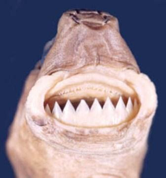
Cookie Cutter Shark Teeth

His first attempt at age 61, was like Penny Palfrey’s in March 2009, but it lasted only 4-1/2 hours when he was bitten by a cookie-cutter shark. It left a three-inch diameter, one-inch deep would on his left leg. This species of shark grows to about 20 inches in length and takes melon-ball sized chunks of flesh from its prey. Spalding said. “I’ll be back in the hunt, back trying to train for the channel again. . . . I’m looking forward to the next time I get out there and finish this channel.” Maui News


An article about the channel in Sports Illustrated back in 1973 (Carlton Fisk was young) had the following title and teaser:

“Olly As In Jolly, Haha As In Crutch”

“The Alenuihaha Channel was no laughing matter; it was miles of thrashing current and biting wind that tossed the ocean racers. And it was only the beginning of the first around-a-state contest ever held.”

The article by Richard W. Johnston went on to say that yachtsmen would do well to memorize the name: “olly as in jolly, nooey as in hooey, and haha as in crutch.” I am certain that the haha part is not haha funny but probably more like haha sad. So the “crutch” part is either “funny as a rubber crutch,” or some nautical term, insider-joke that misses me totally. Richard W. Johnston

If anyone reading this knows, please leave a comment.

Aloha

Tuesday, June 8, 2010

"Time and Tide Wait for No Man"

Continuing the topic of tides, we now know why there are two high tides and two low tides at most places on the earth daily (see “Swimming with the Tide in Hawaii”). How high or low the tides are depends on the relative location of the earth, moon and sun.

Spring Tides

When the moon is full or new, the gravitational pull of the moon and sun are combined. The combined gravitational attraction of the two bodies produces a very strong tide that “springs forth” onto the coast, and thus is called a spring tide. (Spring tides have nothing to do with the season of the spring.) They occur when the Earth, the Sun, and the Moon are in a line. The gravitational forces of the Moon and the Sun both contribute to the tides. Spring tides occur during the full moon and the new moon.

Redfishpro.org

Neap Tides

During the moon's quarter phases the sun and moon work at right angles, causing the bulges to cancel each other. The result is a smaller difference between high and low tides and is known as a neap tide. Neap tides are especially weak tides. They occur when the gravitational forces of the Moon and the Sun are perpendicular to one another (with respect to the Earth). Neap tides occur during quarter moons. http://home.hiwaay.net/~krcool/Astro/moon/moontides/

Tide Charts

http://freetidetables.com/?tides_data%5bttiq%5d=-16,2

Tide charts show a tremendous amount of information (please follow link to see larger size). They show the times of sunrise, sunset, moonrise and moonset. They also show the phase of the moon and the times of the two high and two low tides each day. And the vertical axis shows the height or depth of the tide in feet as a variance to the Mean Lower Low Water (MLLW) level – defined in the last post.

You can see for example that in Hilo the high tide this week will be on Saturday with the new moon at about three feet above MLLW and occurring at 15:55 (3:55pm), and lowest tide that day will be about 0.7 feet below MLLW at 8:30am. And these are spring tides because the sun, moon and earth are in a straight line with each other.

Four feet is about the maximum variance of the tides at Hilo which isn’t much as you can see by the two photos below taken from our home here.

Low Tide

High Tide
The highest tides in the world at over 50 feet (!) are at the Bay of Fundy in Nova Scotia, Canada. The Bay of Fundy even has an interactive site where you can see the impact of such tides at http://www.bayoffundytourism.com/.